 Syken metatietopalvelu
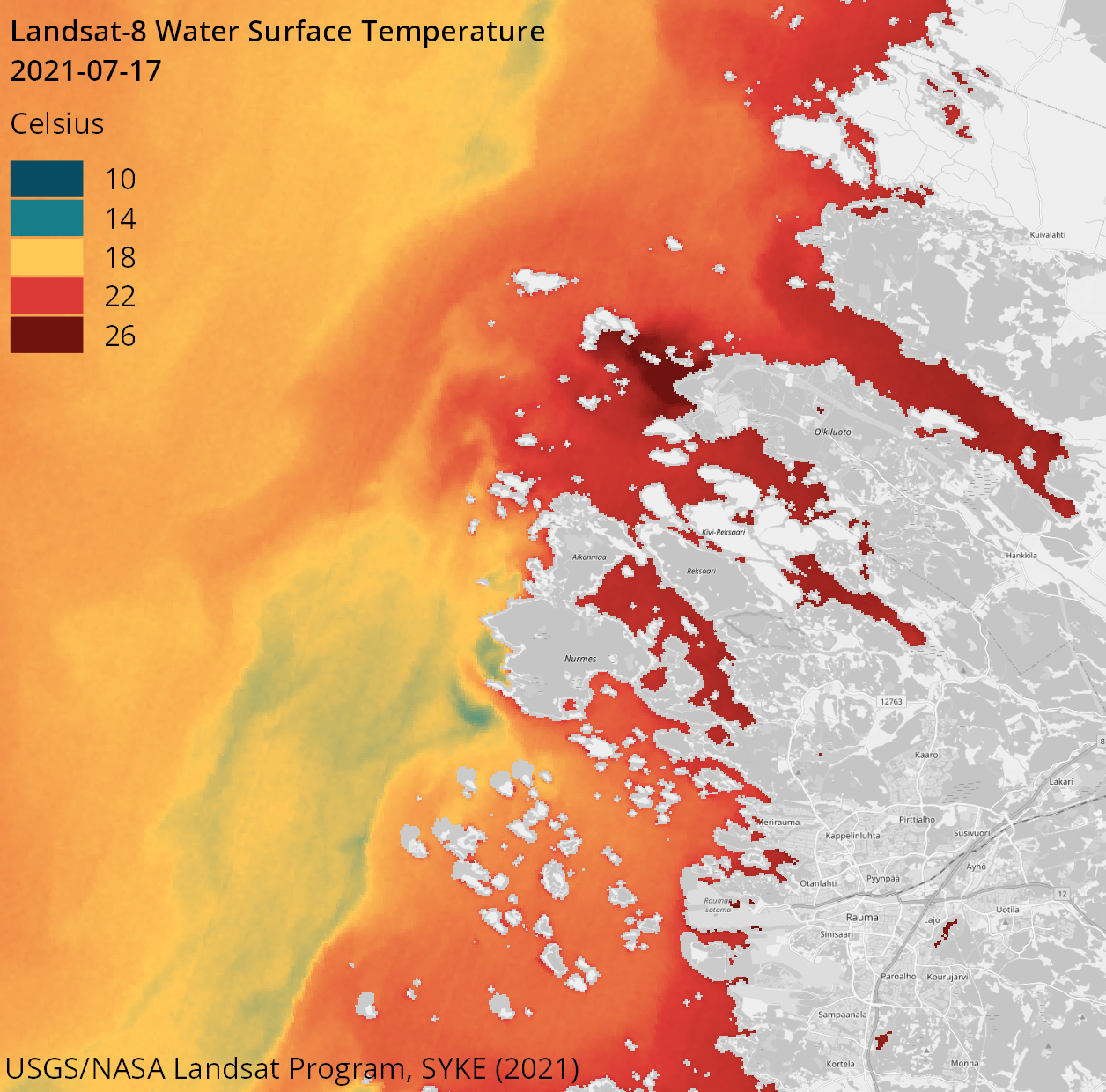
Suomen rannikon ja järvien päivittäinen tarkan resoluution pintalämpötila-aineisto (Landsat-8/9, 100 m) / Daily high resolution water surface temperature of Finnish coast and lakes (Landsat-8/9, 100 m)
[FI] Suomen järvien ja rannikkoalueiden pintalämpötilaa seurataan päivittäin tarkan maastoerotuskyvyn pilvettömien satelliittiaineistojen avulla.
Pintalämpötilatulkinta perustuu Yhdysvaltain geologian tutkimuskeskuksen (USGS) Landsat-8 satelliitin TIRS-instrumentin ja Landsat-9 satelliitin TIRS-2-instrumentin keskipäivän havaintoihin. Tulkinta on laskettu ilmakehäkorjatusta ja veden emissiivisyyden huomioivasta Level-2-aineistosta. Maa- ja pilvialueet on tunnistettu ja poistettu aineistosta automaattisella vesialueiden tunnistusmenetelmällä, jonka jälkeen tulkinta on laatuvarmennettu manuaalisesti.
Aineiston lämpötilat kuvaavat vesialueiden pintakalvon lämpötilaa Landsat-satelliittien ylilennon aikaan havaintopäivinä noin kello klo 11–12 Suomen aikaa eli klo 9–10 UTC0-aikaa. Havainnot edustavat vedenpinnan päivälämpötiloja. Aineiston maastoerotuskyky on 100 m x 100 m.
Aineistoa on kehitetty projektissa Tailored downstream applications/products–from Copernicus to coastal and inland water monitoring ( https://www.syke.fi/en/projects/tailored-downstream-applicationsproducts-copernicus-coastal-and-inland-water-monitoring). FPCUP-projekti on rahoitettu European Commission päätöksellä FPA no.: 275/G/GRO/COPE/17/10042.
Aineisto kuuluu SYKEn avoimiin aineistoihin (CC BY 4.0).
Käyttötarkoitus: Itämeren ja Suomen järvien pintalämpötilan seuranta.
***
[EN] The surface temperature of Finland’s lakes and coastal areas is monitored daily using cloud-free satellite data with high spatial resolution.
The surface temperature interpretation is based on midday observations from the TIRS instrument onboard the U.S. Geological Survey’s (USGS) Landsat-8 satellite and the TIRS-2 instrument onboard the Landsat-9 satellite. The temperature is computed from the atmospherically corrected and water emissivity adjusted Level-2 data. Land and cloud areas have been identified and removed from the dataset using an automated method, after which the products undergo manual quality control procedures.
The temperatures in the dataset represent the surface film temperature of water bodies at the time of the Landsat satellites’ overpass, which occurs around 11:00–12:00 Finnish time (09:00–10:00 UTC0) on observation days. These observations represent day-time temperatures. The spatial resolution of the dataset is 100 m × 100 m.
Dataset has been developed in project Tailored downstream applications/products–from Copernicus to coastal and inland water monitoring ( https://www.syke.fi/en/projects/tailored-downstream-applicationsproducts-copernicus-coastal-and-inland-water-monitoring) The FPCUP project is financed by the European Commission under the FPA no.: 275/G/GRO/COPE/17/10042
***
WMS-palvelin / WMS service endpoint: https://geoserver2.ymparisto.fi/geoserver/eo/wms
WMS-taso / WMS layer: EO_HR_WQ_LC8_SST
Simple
Identification info
- Title
-
Suomen rannikon ja järvien päivittäinen tarkan resoluution pintalämpötila-aineisto (Landsat-8/9, 100 m) / Daily high resolution water surface temperature of Finnish coast and lakes (Landsat-8/9, 100 m)
- Date (Publication)
- 2021-08-20
- Point of contact
-
Organisation name Electronic mail address Role Suomen ympäristökeskus / Finnish Environment Institute (Syke
Point of contact
-
SYKE resource classification
-
-
Satelliittihavaintotieto
-
- Keywords
-
-
Ei-Inspire
-
TARKKA
-
status assessment
-
Resource constraints
- Use constraints
- Other restrictions
- Other constraints
-
Creative Commons Nimeä 4.0 Kansainvälinen
[FI] Syke on mainittava lähteenä, jos tuotteita käytetään julkaisuissa tai esityksissä tai saatetaan muulla tavoin yleisön saataviin.
Landsat-8/9 aineistoihin perustuva lämpötila: "Syke-aineisto, USGS/NASA Landsat Program (vuosi)"
Lisätietoja: https://wwwi4.ymparisto.fi/i4/fin/eowiki/aineistojen_kayttoluvat.html
***
[EN] Syke must be cited as a source if the products are used in publications or performances or otherwise made available to the public.
Surface temperature based on Landsat-8/9 data: "Syke data, USGS / NASA Landsat Program (year)"
More info: https://wwwi4.ymparisto.fi/i4/eng/eowiki/license_information.html
- Access constraints
- Other restrictions
- Other constraints
- no limitations
- Spatial representation type
- Grid
- Metadata language
- English
- Topic category
-
- Environment
- Oceans
Temporal extent
- Begin
- 2014
Spatial extent information
))
- Unique resource identifier
- EPSG:4326
- Codespace
-
EPSG
- Distribution format
-
- GeoTiff ( -)
Digital transfer options
- OnLine resource
-
Protocol Linkage Name https://www.syke.fi/tarkka Tarkka-palvelu/service
https://geoserver2.ymparisto.fi/geoserver/eo/ows?service=wms&version=1.3.0&request=GetCapabilities GetCapabilities-dokumentti
https://wwwi4.ymparisto.fi/i4/fin/eowiki/aineistot_aineistot.html Lisätietoa Syken EO-wikissä
https://wwwi4.ymparisto.fi/i4/eng/eowiki/datasets_start.html More information in Syke's EOwiki
https://geoserver2.ymparisto.fi/geoserver/eo/wms?service=WMS&version=1.1.0&request=GetMap&layers=eo:EO_HR_WQ_LC8_SST&time=2021-09-28&styles=&bbox=17.498,57.5,31.501,66.503&width=768&height=480&srs=EPSG:4326&format=image%2Fpng%3B%20mode%3D8bit WMS-esimerkki / WMS example
https://www.syke.fi/fi/ymparistotieto/avoimet-rajapinnat/satelliittihavaintojen-rajapinnat Satelliittihavaintojen rajapinnat/EO web map services
- Hierarchy level
- Series
- Statement
-
-
Metadata
- File identifier
- {12E84794-2793-4B20-B870-1DB6492B37D3} XML
- Metadata language
- English
- Character set
- UTF8
- Hierarchy level
- Dataset
- Date stamp
- 2026-11-18T12:40:32.273023Z
- Metadata standard name
-
ISO19115
- Metadata standard version
-
2003/Cor.1:2006
- Metadata author
-
Organisation name Electronic mail address Role Suomen ympäristökeskus / Finnish Environment Institute (Syke)
Point of contact
Overviews
Spatial extent
)))
Provided by
